9. Mapping Mars
We did not invent maps on Mars; we inherited them, argued with them, and then made them behave.
The old quadrangles from the lunar and Mariner eras were honest tools — patchworks tailored to mission footprints and projection limits. Good science. Bad logistics. When you try to build a society on a world with few rivers, no nations, and too much dust, your atlas can’t be a museum of historical accidents. It must be a machine.
So we took the legacy ideas — quadrangles, lat–lon tiling, polar caps that misbehave — and standardized them into a single, nested system that any crew, rover, or AI could use at 04:14am on a Monsol with a dying battery.
We called it the Mars Grid System, the MGrid. Later we applied it to other bodies — lunar maria, Ceres’ scarred ice-rock, and the big cold moons where seas are methane and the wind has opinions. But it began here.
♦
The inheritance, briefly. The Moon had LQ/LAC grids (30 large quads; 144 at finer scale), boxes bent to 1960s satellite photography capabilities. Mercury’s H-series followed Mariner 10 and MESSENGER footprints; Venus used V-quads keyed to Magellan’s radar mosaics. Mars itself wore the MC-01…MC-30 scheme — sensible for geologists, variable in size by latitude, anchored to what Mariner 9 could see. 1960s technology.
These were fit-for-purpose maps. Their purpose was not settlement. A rover could live inside them; a civilization could not grow predictably from them. They changed widths with latitude, changed names with committees, and changed rules with missions.
Imagine running rail standards from Trantor with a different gauge every province, madness! Our first winter on Mars taught us to stop being romantic about legacy cartography.
♦
So early Martian pioneers built something else instead. The MGrid is a six-level, cleanly nested hierarchy from continental to city-block scale:
Quads (big continental plates that read like chapters).
Zands (Zone × Band intersections; the “countries” you can brief in a meeting).
Provinces (2° × 5°; corridor-building units).
Sectors (1° × 1°; 60km county-scale squares for regional siting).
Tiles (6′ × 6′; local 6 km squares).
Clicks (1′ × 1′; ~1 km squares; the atoms of the grid).
The trick isn’t the names. It’s the regularity: each level subdivides the one above it with integer math; polar regions follow wedge rules; codes are short, neutral, and memorable. The grid doubles as a language of intent: “M–Gamma, Z0514, Province P-3, Sector S-27, Tiles T-45/46, Clicks C-181–C-186” is not poetry, but it gets a hauler to the right dune without asking which side of which crater the foreman “meant.”
♦
But why did we need it? Well, Mars is a cartographer’s paradox: a world as large as all of Earth’s continents, but with few crisp cues. No blue lines to follow. Vegetation maps? None. Political borders? Please. Relief is gentle for thousands of kilometers, then violent chaos for a day’s drive — Tharsis, Valles, Hellas — and back to gentle again. Dust hides edges; the atmosphere changes its mind each season; ice refuses to be honest or static at the surface.
You cannot plan with vibes. You need predictable buckets of land area that hold data, contracts, utilities, and arguments. The MGrid gave us the buckets.
♦
Quads — the planetary chapters.
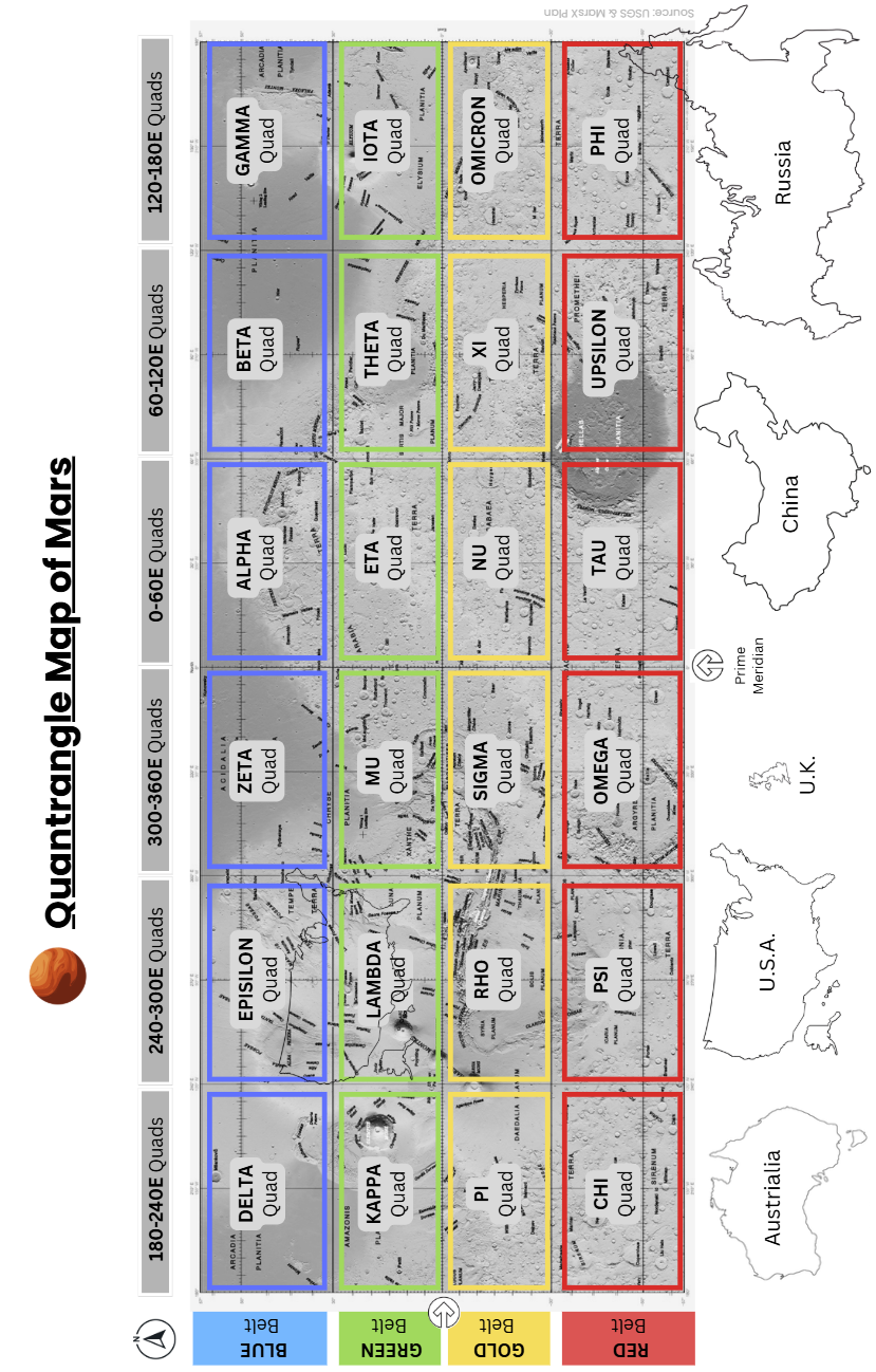
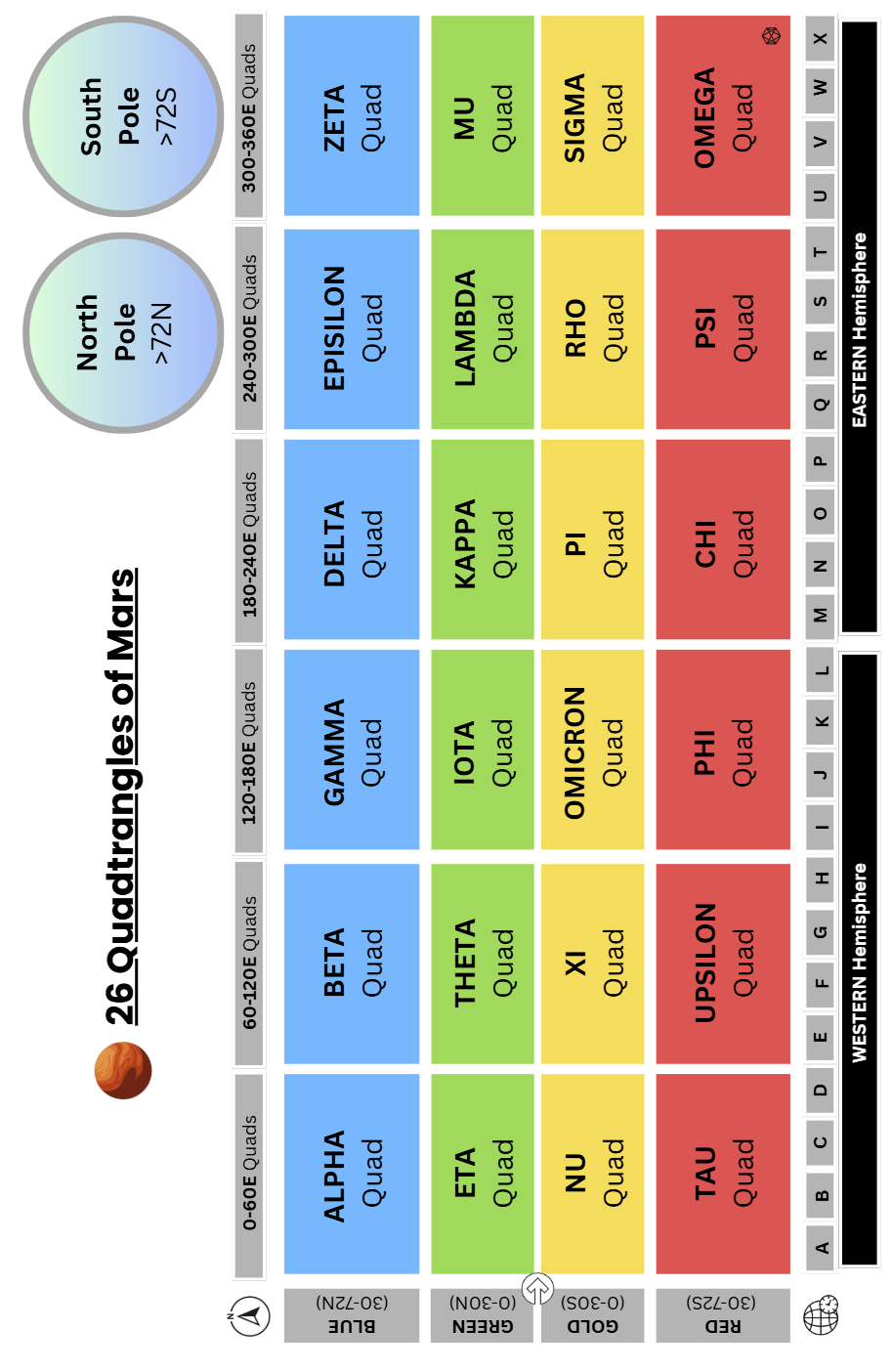
We kept the world in 26 Quads: 6 low-latitude north + 6 low-latitude south (0–30° bands) and 6 mid-latitude north + 6 mid-latitude south (30–72° bands), plus 2 polar caps (≥72°). Quads are not “operational”; they’re cultural and strategic. We told stories and set budgets at this scale: North Low–Kappa isn’t “friendly to rail”; it’s an epic—trade winds, dust climatology, three great plains. When an orbital drops a new map release, Quads are the covers.
Zands — the executive map.
Intersection of one 15° Zone and one 6° Band. There are 24 Zones pole-to-pole and 24 Bands between ±72°, with the caps sliced into 24 wedges each. Zands are where strategy becomes geometry. They align with timekeeping (Zones = time zones) and logistics (corridors prefer long axes). We compared candidates at this level: ice proximity, hazard density, ruling grades, and padport geometry. If you can brief a planet in an hour, you’re speaking Zand.
Provinces — corridors and commitments.
Inside each Zand, a 3×3 grid of 2° × 5° Provinces. About 36,000 km² each—big enough for a region’s worth of wind, small enough to close a budget. We laid corridors at this scale: road then rail, fiber trunks, and the future pipeline you swear you won’t build (until you do). Risk players love Provinces—they look like territories. Engineers love them more — they’re the stride length of civil works.
Sectors — regional siting.
1° × 1° squares ′ (~60 × 60 km) — the county where decisions finally acquire nouns. A Sector holds one depot, two quarries, three good mistakes, and a decent hill with line-of-sight. We placed depots, switchyards, tank farms, and contingency pads at this level. Your fire code, evac math, and maintenance takt start to make or break here.
Tiles — the workday grid.
6′ × 6′ (~6 × 6 km). The Tile is the unit a shift lead can hold in their head: a solar wedge, an intake farm, a yard, a trench line — 36 km² of solvable problems. Mission Control learned to stop saying “the dune” and start saying Tile T-45. The bots understood either way; the crews preferred the tile.
Clicks — the atoms.
1′ × 1′ (~1 km²). On Mars sphere 1 arc minute is a few meters short of a kilometer, so the naming of these as Clicks was easy. Clicks are for siting airlocks, plotting haul loops, and arguing with survey about a berm that is two meters to the wrong side of common sense. They are not equal area, but they are equal habit: one kilometer is one kilometer; the brain loves that. We plan by the Click and measure with the rover wheel. (On “Dune-like” worlds — no rivers, all fines, occasional rock spur and, mercifully, minus the worms — Clicks are the difference between a map and a life.)
♦
Was it perfect, no not quite, but that was Polar mischief. Longitude squeezes toward the poles. Old schemes either exploded the number of boxes or let them shrink to nonsense. Our rule: wedge the caps. Above ±72°, each 18°-tall cap is cut into 24 polar Zands, then subdivided so Provinces and Tiles stay near their sub-polar areas. Rows keep 1° tall Sectors; columns widen in minutes of longitude as needed. The result feels the same to crews whether they’re in Meridion or on the sastrugi.
♦
MGrid wasn’t just a map; it was permission architecture. It was the basis of our Martian operating system. The City Mayor’s needed it to discuss trade; the Chief Operators needed it to work out logistic corridors; and the Chief Engineers needed it to work out power grids. Everyone needed it to talk to one another — and Earth.
It let us say, “This Zand is for industry satellites; this one remains survey-only.” It let us chain Provinces into corridors without re-litigating every dune. It made contracts portable: a Tile is a Tile on Mars, on the Moon, on Ceres. When we discovered a better coupler spec, we updated the Sector-book and every contractor knew where the change applied. The grid turned “place” into policy.
It also made simulation honest. You could run ten centuries of settlement growth like a strategy game (you know the ones), and then hand the save file to civil works with coordinates that mean the same thing under wheels.
♦
Most importantly the levels worked together. A Quad framed the chapter: South Mid–Tau has katabatic habits, sparse outcrops, great long grades. Inside it, a Zand picked a stage: Z0514 (Zone 05 × Band 14) lives on a trough that wants to be a road. A Province locked a pledge: P-3 carries the corridor right-of-way and the materials reserve; every other plan must not strangle it. A Sector set the yard: S-27 fits the depot, the switch, and the tank farm upwind. A cluster of Tiles kept fabrication, intakes, and PV honest; a ring of Clicks told the bots where to stop digging and the kids where not to sled.
You could cross-index absolutely everything — weather, ice radar returns, dust optical depth, accident rates, fleet uptime — and keep it coherent at each level. That’s what “mapping” really means when the stakes move freight.
♦
The first hundred years of settlers did not merely stake out land; they standardized a planet. They made a grid clean enough that later Martians could inherit it and outsiders could adopt it. Titan’s methane crew use MGrid now. The lifters on the Moon’s south-pole ridges use it. The prospectors on Ceres — bless their safety briefings — use it. You can read a docket stamped “Jovia–Ganymede–Zand N-Halo” and know roughly what to expect. That gift came from the way Mars refused to give us easy landmarks and the way those early engineers refused to accept that as an excuse.
♦
The MGrid, for all its neatness, was built for a reason: to plan and site what people would live in and what industry would run on. The pioneers used it first to place settlements and satellites — capital sites and the industrial outliers that paid for them. They chose Provinces to protect long spines, Sectors to anchor yards and intakes, Tiles to lay out loops, halls, and heavy belts you’ll meet soon by their proper names, and Clicks to thread fiber and footpaths between them.
That is where this atlas hands the baton to the city plan. We will now turn from the coordinates to the places — what they looked like and why, and how the grid helped us choose them. And ultimately how those choices grew into streets you cannot bypass without paying for your principles.
♦
The whole MGrid stack at a glance.
Level | Lat–lon rule (sub-polar) | Typical size | Canonical nesting | Global count* | Primary use |
Quad | 6 Bands × 4 Zones (≈ 30/42° × 60°) | ~2,100 × ~3,600 km | 26 per Globe | 26 | Continental strategy, heritage |
Zand | 6° × 15° | ~360 × ~900 km (~324,000 km²) | 20/28 per Quad | 624 (576 sub-polar) | Operational regions, time-zones |
Province | 2° × 5° | ~120 × ~300 km (~36,000 km²) | 9 per Zand | 5,616 | Corridors, macro siting |
Sector | 1° × 1° | ~60 × ~60 km (~3,600 km²) | 10 per Province (2×5) | 53,568 | Regional siting, depots |
Tile | 6′ × 6′ | ~6 × ~6 km | 100 per Sector (10×10) | ≈5.19 M | Local ops, layouts |
Click | 1′ × 1′ | ~1 × ~1 km | 36 per Tile | ≈193.8 M | Site units, EVA plans |
*Global counts include polar wedge logic; east–west sizes shrink with latitude ~cos φ.
Keep this one mnemonic: Quad > Zand > Province > Sector > Tile > Click. From “continent” to “block” in six steps, each roughly a tenfold refinement in area.