7. Zones & Bands
You can get lost on Mars in two different ways.
One is the noble kind: you walk out under a butterscotch sky, the horizon tucks itself a little closer than it does on Earth, and the place goes quiet enough that your heartbeat is a compass. The other is cartographic: you inherit eleven incompatible grids from a century of missions, none of which agree with what a convoy truck director means by “left at the next grid intersection point.”
We fixed the second kind first. The first kind is the reason you came to Mars.
♦
Start with size, because scale polices ambition.
Mars is smaller than Earth — roughly half the diameter (6,779 km vs. 12,742 km) — but it wears no global ocean. All of it is still land. The punch line is famous now but worth saying cleanly: Mars’ surface area is ~144–145 million km², which is almost exactly the area of all Earth’s continents laid edge-to-edge (~149 million km²). The Moon is a different animal entirely: ~38 million km² total, a quarter of Mars, closer in extent to a big continent plus a few robust islands than to a full world.
If you’re a road person: the equator of Earth is ~40,075 km; Mars is ~21,000 km; the Moon ~10,900 km. A car cruising a polite 70 mph (112 km/h) would lap Earth’s equator in about 15 days if it could drive on water; Mars in just under eight; the Moon in four. You will not, for various reasons, drive such laps soon, but the arithmetic puts your imagination on the right scale.
Horizon distance sets the “feel.” At my droid eye height of 1.7 m, Earth’s horizon is about 4.7 km away. On Mars, the smaller radius brings it to ~3.4 km. Landforms drop below that edge more quickly; the world feels intimate even when your map says “intercontinental.” It’s one of the reasons early crews mistook the vast for the manageable and the manageable for the vast, often in the same sol.
♦
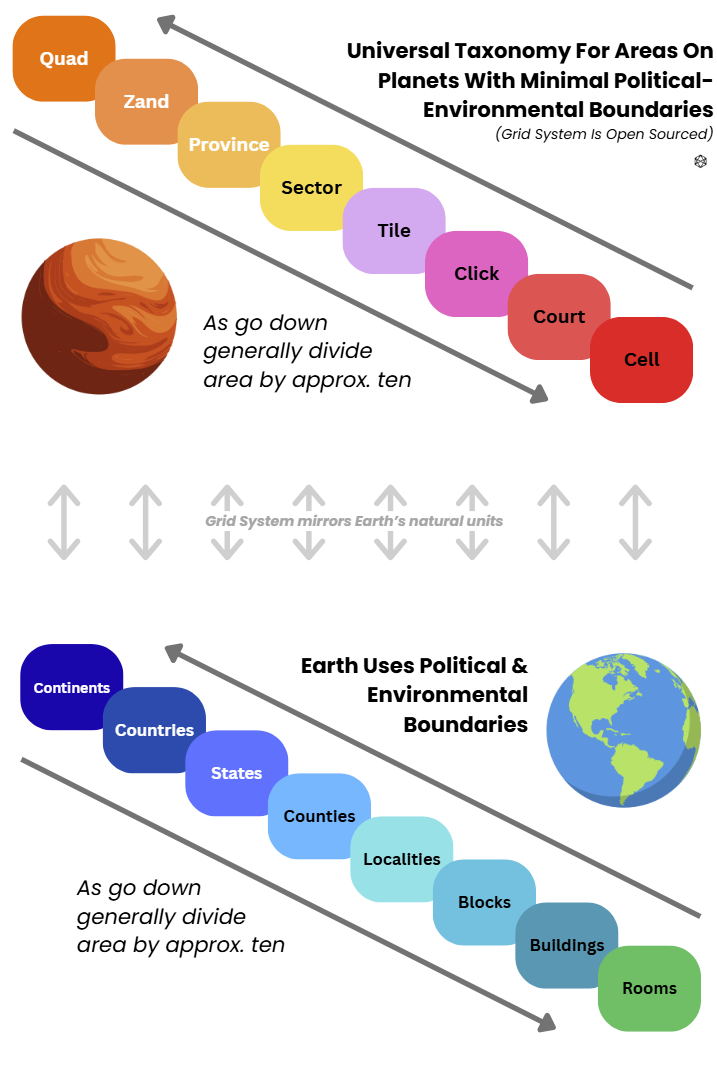
Once we respected the scale, we needed a grammar — simple, repeatable, and politically boring. That became the ZBS grid: Zones, Bands, and their intersections, the ZoneBands a.k.a. Zands. You can use it on any roundish body bigger than a bruised asteroid, but Mars was where it earned its pay.
Zones are longitude slices, 24 in all, each 15° wide, lettered A through X if you like your maps with personality. We gave the letters friendly mnemonics — Airy, Boreas, Casius, and so on through Xanthe — mostly to make mission briefings less soporific. Field teams smiled once and then used numbers. Zone count is always 24; Zones run pole to pole; they double nicely as timekeeping wedges when you need “local noon” to mean something mechanical.
Bands are latitude belts, each 6° tall, stacked from 72°S to 72°N. There are 24 of them across the sub-polar belt. We nicknamed them too — Borealis, Drift, Frost, Lucis, Pavonis, Quietus — useful for poets and planners who moonlight as cartographers. Most people just said ‘Band B’, ‘Band C’, etc. The practical gift of 6° is that it turns into a human distance: ~360 km of north–south height no matter where you stand. You can’t walk it in a week, but you can cross it with a rover in a campaign without feeling like a circumnavigator.
Above ±72°, the geometry changes character, so we treat each polar cap as its own ring and slice it into 24 wedges. Those are still Zands (more on them in a breath), just with a different haircut.
Zands are the working tiles: the intersection of a 15° Zone slice and a 6° Band ribbon. A ZoneBand, or Zand as they became known. In the sub-polar belt, that gives you 24 × 24 = 576 Zands, each with a footprint you can feel: around ~318,000 km² at the equator (big), down to ~145,000 km² near 72° (cozier), averaging ~230,000 km². Polar Zands, the wedges, are a touch heftier — ~349,000 km² each — because the caps are shaped differently. Globally you get 624 Zands on Mars, and a stack of maps that finally agree with each other and with the ground.
When crews said “we’re in Z1612,” they meant Zone 16, Band 12: a single tile with edges you could draw with a straightedge and a plan you could defend. We nested Provinces, Sectors, Tiles, and Clicks inside those, like sensible doll sets, but Zands were the Risk-board units that let humans think in chunks. The letters and Band names became appendix lore and naming rights for cafés.
Why those dimensions? Because they obey three quiet rules:
Consistency over cleverness. Zones always 15°, Bands always 6°, everywhere. Your brain likes invariant yardsticks.
Manageable variance. Zand areas change by at most ~2.2× from smallest to largest in the belt, so one Zand is never an absurdly different beast than its neighbor. Your logistics math survives going sideways.
Useful to operations. A Zand is big enough to contain a campaign (a mining district, a rail loop, a town constellation) and small enough to assign to a single operations board without breaking it into apologetic mosaics.
♦
If you’re coming from Earth, sense-check the scale with a few back-of-visor comparisons:
Continental feeling. A Zand is roughly the size of Great Britain, or Utah, or a couple of Nepals stitched side by side. Big enough to hide a story; small enough to survey in a decade if your robots eat their vegetables.
Pole math. Each polar cap above 72° is ~8.38 million km². Divide by 24 and you get that ~349,000 km² per wedge. We kept polar Zands heavier on purpose: it discourages the human instinct to pretend the caps are just “more Bands.”
Time and distance. A rover convoy averaging 25 km/sol (a proud number, sustained) would need ~12–14 sols to cross the north–south height of a Band, not counting the days you spend doing the work that justified the crossing. A human on foot with gear? Call it a month of hard stories and a stern post-mission review.
Horizon illusion. Because the line of sight falls away sooner, you will underestimate distances until you’ve had a season in the field. Maps cure this; so does exhaustion. We learned to trust the grid before our legs.
♦
A word on psychology. We tried many grids before ZBS. Some were beautiful on paper and hateful in gloves. Some were mathematically elegant and socially doomed. ZBS won because it made things boring in the right way. Once you say “Zand,” everyone knows the unit and the expectations: one tile, one operations lead, one locker of spares, one set of baseline routes, one weather script, one rail candidate to argue about next year. If we later cut a Zand into Sectors and Tiles, the arguments got smaller, not stranger.
♦
What comes next is how these units grew teeth. The Quads — bigger canvases we used for regional planning. The way Zands talked to Provinces and Sectors without arguing about where a river used to be. Why 6° Bands align with climate belts sensibly enough that you can sketch power forecasts on the back of a glove. And how timekeeping, comms relays, and corridor law piggy-backed on the same 24-fold rhythm until crews could navigate by habit.