
8. The Quads
Quadrangles were not ours to invent. Long before we drove stakes into Mar’s dust, cartographers were already slicing other worlds into rectangles that only a globe could forgive.
The Moon wore LQ and LAC plates like a mosaic of early triumphs; Mercury carried H-series panels tuned to Mariner and MESSENGER’s lopsided gaze; Venus bore V-tiles shaped by Magellan’s radar swaths; Mars itself lived for decades in MC-01 to MC-30, a patchwork that fit mission film reels and photogrammetry more than it fit the planet.
Useful, honest — and variable in ways that multiplied pain once you tried to talk across worlds.
The variability had reasons. Telescopes missed longitudes; cameras overflew stripes; polar convergence punished “equal rectangles.” So each body earned its own logic: fewer tiles near the poles here, bigger slices there, bands that bent around a data void because a spacecraft did. As an archivist, I admire the pragmatism. As an engineer who had to schedule convoys and argue about which map tile owned a broken hauler, I can tell you this: inconsistent grids teach you a second job — translation.
We did what frontline engineers always do with beautiful, inconsistent traditions: we kept the good nouns, standardized the verbs, and made the units fit in a toolbox.
♦
The Quad — formally, the quadrangle — survived the audit. We re-forged it into a cross-body standard: every roughly spherical world of consequence (radius ≳ 500 km) is divided into exactly 26 Quads: 24 in the belts between ±72°, and two polar caps. Each belt Quad spans 60° of longitude by 30° or 42° of latitude; each polar Quad is the cap from 72° to the pole. No more bespoke plate sizes by planet, no more “this quad is special because a camera missed.” The quad is the quad. You can carry it in your head and put it on a bill of lading.
Why 30°/42° lat by 60° long? Because it nests cleanly into the grid we actually use to move and build — Zones and Bands. Zones are 15° slices of longitude (24 of them, doubling as time zones); Bands are 6° tall strips of latitude (24 of them across the sub-polar belts). Five & Seven Bands tall by four Zones wide yields 20 (4x5) & 28 (4x7) Zands (Zone × Band) inside each belt Quad, and these are numbers that lets humans and supply chains count without squinting. Polar Quads keep their own wedge logic, but the ledger stays at 26.
In Quads, the Bands of 6° latitude ribbons, were joined up to became four 30-42° latitude Belts:
Northern Mid-lat “Blue Belt” (30–72°N) — #38B6FF
Blue = ice. This band hosts the latitude-dependent mantles, lobate-debris aprons, and shallow ground-ice that made northern mid-lats the water/cryogen workhorse. Seasonal CO₂ frosts visit, but the headline is H₂O stability and access. The Blue Belt is where “cold resources” live.
Northern Low-lat “Green Belt” (0–30°N) — #7ED957
Green = growth. Not vegetation (we’re still Mars), but the operational “heartland”: low elevations in the northern plains (Arcadia/Utopia/Elysium margins), wide EDL boxes, forgiving corridor grades, and the geography where early hubs sprawled and supply chains matured. The Green Belt is where “Terraforming” begins, and where ‘life’ was found.
Southern Low-lat “Gold Belt” (0–30°S) — #FFDE59
Gold = sun (with a caution stripe). Mars hits perihelion in southern summer, so this belt gets the spiciest insolation of the year — great PV yields when the weather cooperates. It’s also mostly higher terrain (thinner air, harsher EDL margins) with more volatile dust lifting. The Gold Belt is the “solar sweet spot.”
Southern Mid-lat “Red Belt” (30–72°S) — #FF5757
Red = beware. Mars’ ancient highlands/heritage & hazard. Rugged Noachian crust, iron-rich regolith, steep relief, and patchy buried ice in a rougher package. It’s the archetypal “red Mars” you picture, and a good color cue for heavier terrain, stricter traverse planning, and planetary-protection sensitivities. The Red Belt is the “caution zone.”
If this sounds like we engineered a Risk board for the Solar System, that’s because we did. Every body gets the same geometry, the same counts, the same codes. Your rover software doesn’t care whether it’s in M-Theta on Mars or C-Lambda on Ceres; your insurance form does, and it parses both.
♦
The legacy, briefly, so we honor it while we surpass it.
The Moon wore 30 large LQ quads and 144 LAC mini-quads at finer scale, arranged north to south, lon widths shrinking poleward; elegant for telescopes, fussy for logistics. Mercury’s H-series — fifteen quads with fat equatorial bands and skinny caps — reflected the half-lit reach of Mariner 10 before MESSENGER filled in the dark. Venus started coarse (eight continental V-quads), then refined to 62 quads that matched Magellan’s radar mosaics more than latitude. Mars’s MC set — thirty original quads that swelled and pinched with latitude — served geologists superbly; we still annotate with MC IDs when we talk in sedimentary time, but they didn’t align longitudinally or pass a similar size check.
The problem was not that any one scheme was wrong. The problem was that all of them were right for a 1970s yesterday’s imager and tomorrow’s meeting — different kinds of right every time. When you try to route aid from a polar mine on Callisto to a mid-lat yard on Mars and then to a dome-yard on Triton, you do not want your grid to be “right for the instrument.” You want it to be predictable. Also: printable on a crate label.
So: 26 Quads, everywhere. Numbers that rhyme across worlds. A greek coding that a tired human can read and an indifferent AI can validate.
♦
Mars is where the standard earned its boots.
Divide the globe into three working belts: a northern low-latitude belt (0–30° N), a northern mid-latitude belt (30–72° N), mirrored in the south, with polar caps above 72°. In each low and mid belt, you lay four 60-degree-wide Quads around the planet, six Bands tall; that’s 24 belt Quads total (12 north, 12 south), plus North and South Polars. The equator doesn’t get special treatment beyond being equator; the geometry carries through without pleading with projections.
What does a belt Quad “feel” like in area? On Mars, with mean radius ~3,390 km, each low-latitude Quad sits a little over six million square kilometers (call it the size of Australia, give or take a Texas), and each mid-latitude Quad is a little smaller even with more latitude bands because the planet narrows with cos φ. Polar Quads are smaller again in area but heavy in operations, because caps are complicated: ice, dunes, layered deposits, and winds that live on the edge of sastrugi and poetry.
We named the Quads with a simple discipline: polar N and S, then 24 Greek letters northward and southward around the belts — Alpha through Zeta across the northern mid latitudes, Eta through Mu around the northern lows, and so on into the southern mirror (Nu to Sigma for the southern lows, Tau to Omega for the southern mids). The names are banal by design; the maps inside them are not. If you want romance, open the appendix and pick your favorite Quad; it is acceptable to fall for Delta in the north mids if your heart belongs there, or to Omega if you like your deserts with a side of ancient wind.
Operationally, the code matters more than the romance. “M-Tau” tells me I’m in the South-Mid band, Quad Tau, 0–60° longitude; “M-Tau–Z1209” nails me to a 6° × 15° Zand inside it. My convoy planner can route to M-Tau–Z1209 without needing me to explain dunes, dust devils, or the poetry of yardangs. The geometry is the geometry; the ground is the ground.
♦
“But isn’t this just another scheme?” the first-century critics asked, and you could hear the long sigh of geologists who had lived through three mapping epochs already.
The answer is that we changed the objective function. Legacy quadrangles were map products optimized to show geology at some scale long before anyone actually walked on Mars. Our Quads are operational containers optimized to hold Zands cleanly, stack across worlds, and align with timekeeping. They do not compete with geology; they scaffold it. You can overlay MC-25 on M-Eta and be exact about both. You can talk about Syrtis Major the way you’ve always done and still put a box around a convoy when it refuses to leave the garage.
We also made peace with poles by admitting they’re different. Above ±72°, longitude becomes a costume, not a ruler. So we turn each cap into 24 wedges — Polar Zands — that behave in software and do not pretend to be rectangles. The two polar Quads are simply the caps as a whole. The wedge is how you tell a robot which way to fall when its wheel goes light near a scarp.
If this all sounds suspiciously like a sensible orbital with repeating segments, it is because repeating segments are how you build anything that hopes to be maintained. We learned from fiction without needing to confess it: a ring of standard bays beats a zoo of bespoke islands, whether the ring hangs in a blue sky or sits on a cold plain under a butterscotch one. Even Trantor had to pick a block size; it picked bureaucracy. We picked a number you can multiply in your head; we picked practicality.
♦
A few practical consequences worth holding in hand:
Time = space. With 24 Zones in longitude, Quad longitudes snap to timekeeping. Your dispatch window for Zone 05 is also your Z05 shift briefing. This seems small until you try running staggered crews across five Zands and 180 minutes of light.
Equal work, unequal ground. A Quad is a Quad on paper, but the belt it lives in changes its personality. Low-latitude Quads carry smooth basaltic plains, wrinkle ridges, and dust seas that drift like policy. Mid-latitude Quads sit over ice and periglacial puzzles that punish casual trenching. Polar Quads are not “harder”; they are simply honest that ice and wind run the show. The grid doesn’t erase diversity; it gives it a grid reference.
Interoperability beats heroics. A rescue in M-Theta speaks the same coordinates as a delivery on C-Phi (Ceres), and a training sim on T-Eta (Titan). Once you standardize the outer labels, the inner work can afford to be interesting.
Appendix > argument. If you want the names, the stories, and the favorite craters, turn to the back. We put the lore there on purpose so it wouldn’t leak into the standards.
For those who enjoy calibrations: if you drove the equator of Mars at 70 mph (112 km/h), stopping only for machine sympathy, you would circle in about 12 days. Quads are sized to be “continental” in that calculus; a belt Quad is two to three driving days wide, six days tall on a careful traverse — weather, dust, and sanity permitting. Kind of like driving across Australia so I am told, minus the Kangaroos. That’s not a sermon. That’s why the crate label needs to be right.
♦
All of this — the tidy 26, the six-by-four interior grid, the polar honesty — served a further aim: repeatable sub-division. The Quad is not where you stop. It is where you begin to count down.
Inside each belt Quad sits its working anatomy: 24 Zands, each the intersection of a 6° Band and a 15° Zone. Zands are the scale where you publish corridor standards, reserve rail tangents, pick padport headings, and argue about rescue cache spacing without ever once needing a poetic name. They are also the scale where the map becomes a calendar — every 15° you cross is an hour of longitude. That is not an accident. It is the cheapest synchronizer we ever shipped.
But Zands are not where early Mars engineers stopped their cunning. If quadrangles gave us continental shelves, and Zands gave us provinces you can actually patrol, we still needed the things you can build in a season and fix in a night. That is where the hierarchy descends into Provinces, Sectors, Tiles, and Clicks — the grammar of streets, yards, and tolerances that makes “we’ll be there by next sol” true.
We’ll go there next. For now, hold the Quad in your hand like a well-machined part: heavier than it looks, standard thread, fits anything with the same pitch. Pick your favorite Greek letter if you must; the planet won’t mind. The grid made Mars comprehensible at speed. The things we laid on it made it home.
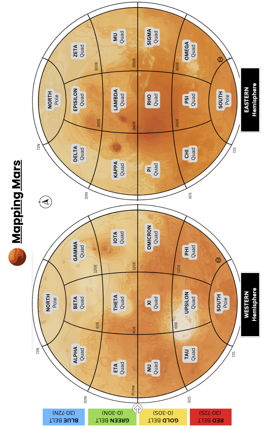
The Mars Quads
Name | # | Lat-Lon | Brief description of the Mars Quad relief and regolith |
North | N | North Polar 72° → 90°N | A circular polar plateau (Planum Boreum) ~1,000–1,200 km across, underlain by north polar layered deposits (NPLD) of water ice and dust. The cap is incised by spiral troughs and the canyon Chasma Boreale, and it is partly encircled by the vast dune sea Olympia Undae. The plateau sits within the northern lowlands (Vastitas Borealis). |
Alpha | α | North Mid 30–72°N | A classic dichotomy-boundary sector dominated by fretted terrains—corridors of mesas and buttes separated by smooth lowlands—between the southern highlands and the northern plains. |
Beta | β | North Mid 30–72°N | Encompasses much of western and central Utopia Planitia—the vast northern plain filling the Solar System’s largest recognized impact basin; includes periglacially modified lowlands with patterned ground and thermokarst-like textures. |
Gamma | γ | North Mid 30–72°N | Eastern Utopia into the northern mid-latitudes, with Galaxias Fossae troughs and parts of the high-latitude Scandia province toward the 70°N limit. |
Delta | δ | North Mid 30–72°N | Dominated by Arcadia Planitia (≈ 34–64°N, 166–210°E)—a northern lowland plain northwest of Tharsis—plus surrounding transitional terrains. This quad is notable for widespread shallow subsurface ice. |
Epsilon | ε | North Mid 30–72°N | A transition from lowlands into the tectono-volcanic margin of Tharsis: includes Alba Mons (a giant, very low-slope shield centered near ~40°N, ~251°E) and large swaths of Tempe Terra, a highly fractured highland block at Tharsis’ NE edge. |
Zeta | ζ | North Mid 30–72°N | From the eastern Tempe Terra margin into Acidalia Planitia—a smooth, dark-toned lowland plain north of Chryse, receiving outflows from Kasei and neighboring systems (lower latitudes). This quad showcases the muted, smooth northern plains and enigmatic mounded terrains. |
Eta | η | North Low 0–30°N | Dominated by the western half of Arabia Terra, an ancient, high-standing upland marked by deeply eroded, densely cratered terrain and widespread layered sedimentary mounds inside craters. The quad straddles the northern edge of the cratered highlands as they slope toward the northern lowlands. |
Theta | θ | North Low 0–30°N | A geologically diverse sector including Syrtis Major Planum (dark, low-relief shield volcano), the Isidis Planitia impact basin, and the Nili Fossae–Jezero region with widespread carbonate-bearing and hydrated silicate rocks. |
Iota | ι | North Low 0–30°N | Encompasses the Elysium volcanic province—Elysium Planitia/Mons—and the tectonic–volcanic Cerberus Fossae fissures that source Athabasca/Marte Valles. The InSight lander touched down on Elysium Planitia (4.5°N, 135.9°E), a flat, rock-poor sand and pebble surface ideal for geophysics. |
Kappa | κ | North Low 0–30°N | A classic volcanic–plains sector: Amazonis Planitia (among the smoothest plains on Mars) and the eastern apron of Olympus Mons with its towering basal scarp and aureole deposits. Parts of the western Medusae Fossae Formation (MFF) extend into this longitude band. |
Lambda | λ | 0–30°N | The NE Tharsis flank and adjoining Lunae Planum, including Ascraeus Mons (~12°N, 255°E) and Pavonis Mons (~0.8°N, 247°E). At the NE margin, Echus Chasma—a tectono-volcanic trough—forms the source region of Kasei Valles, one of Mars’ largest outflow channels. |
Mu | μ | North Low 0–30°N | A northern lowland sector receiving the termini of major outflow systems: Chryse Planitia (Viking 1 landing) and the southern Acidalia Planitia (site of enigmatic mounded terrains). Channels including Kasei, Maja, Tiu, Simud, and Ares Vallis (Pathfinder landing) debouch here from the highlands and Tharsis. |
The Mars Quads
Name | # | Lat-Lon | Brief description of the Mars Quad relief and regolith |
Nu | ν | South Low 0–30°S | Southern highlands bordering the prime meridian, dominated by ancient Terra Sabaea/Sinus Sabaeus uplands: rolling, cratered, with scattered valleys and wind-worked plains. The 0° longitude reference (Airy-0) lies here, embedded in crater Airy. |
Xi | ξ | South Low 0–30°S | Classical Mare Tyrrhenum/Iapygia–Tyrrhena Terra belt with archetypal Hesperia Planum ridged basaltic plains and the low, ancient volcanoes Tyrrhena Patera and Hadriacus Mons. |
Omicron | ο | South Low 0–30°S | The Aeolis sector including two iconic rover sites: Gale Crater (Curiosity) and Gusev Crater (Spirit). Fluvial systems (Ma’adim Vallis) and Medusae-Fossae-related yardang fields fringe the belt. |
Pi | π | South Low 0–30°S | Tharsis-foreland to Memnonia/Syria–Claritas sector: volcanic plains (Daedalia Planum), broad tectonic troughs, and the western reaches of equatorial mantles including parts of the Medusae Fossae Formation (MFF). |
Rho | ρ | South Low 0–30°S | The western–central Valles Marineris province and Phoenicis–Syria–Claritas highlands: faulted plateaus, graben swarms, and canyon heads (Noctis Labyrinthus) transitioning east into the great chasmata. |
Sigma | σ | South Low 0–30°S | Transition from eastern Valles Marineris into Margaritifer Terra/Sinus Sabaeus: chaos terrains and outflow source regions feeding toward Chryse, plus classic crater basins with deltaic deposits. |
Tau | τ | South Mid 30–72°S | Western Noachis Terra and parts of Terra Cimmeria: classic ancient highlands sloping toward the Hellas rim to the east. A showcase of heavily cratered uplands, dune-filled crater floors, and periglacial mantles. |
Upsilon | υ | South Mid 30–72°S | The Hellas Planitia basin and surroundings: the deepest, broadest impact depression on Mars, ringed by rugged mountain chains (Hellespontus, Malea) and backed by Promethei Terra to the east. |
Phi | φ | South Mid 30–72°S | Eastern Terra Cimmeria merging into the western Phaethontis region: old cratered plateaus with widespread slope gullies, mantled terrains, and tectonic fabrics linking into Sirenum structures to the east. |
Chi | χ | South Mid 30–72°S | Central Terra Sirenum: densely cratered Noachian crust with classic gully locales (e.g., Newton Crater sector), Sirenum Fossae extensional fabrics, and possible ancient basin remnants toward the Eridania province. |
Psi | ψ | South Mid 30–72°S | Southern flank of Thaumasia into Aonia Terra and Icaria Planum: tectonized highlands south of Valles Marineris with corridors of chaos/tectonic troughs, cratered plateaus, and widespread aeolian veneers. |
Omega | ω | South Mid 30–72°S | Argyre Planitia and surrounds: a large, deep impact basin (second only to Hellas) encircled by rugged ranges (Nereidum, Charitum Montes) and draining toward Chryse via outflow systems to the north. |
South | S | South Polar 72° → 90°S | The Planum Australe plateau hosts thick south polar layered deposits (SPLD) with a distinctive permanent CO₂ veneer (the Residual South Polar Cap, RSPC) overlying water ice. The region is dissected by large canyons (Chasma Australe; Promethei; Ultimum) and flanked by circumpolar dune fields on the surrounding highlands. |